

Why are you still waiting weeks for a paper report whilst your investment strategy demands real-time precision? In 2026, the traditional site visit is no longer just a bottleneck; it’s a liability that leads to valuation errors and missed opportunities. Adopting digital property surveying is the only way to bypass the frustration of chasing paper floor plans that should’ve been digital from day one. It’s time to stop letting manual processes dictate your deal speed or inflate your overheads.
This guide explores how modern technology transforms physical inspections into high-speed, data-driven insights. By moving away from slow, paper-based systems, you gain instant access to building data that integrates directly into your investment calculators. We’ll show you how to reduce transaction times and eliminate the high costs of manual site visits for large portfolios. You’ll discover how smarter technology creates a seamless path to faster acquisitions and more accurate valuations. This is the future of property intelligence, built for speed and clarity.
Key Takeaways
- Learn how LiDAR and AI modelling have replaced manual tape measures to set a new speed standard for 2026.
- Discover how digital property surveying provides instant, accurate data that satisfies lenders and accelerates property acquisitions.
- Understand the transition from raw point-cloud scans to structured BIM models for more precise investment analysis and visualisations.
- Identify the best methods for centralising survey, legal, and mortgage data into a single, high-speed digital workflow.
- Explore how integrated data feeds directly into AI valuations to ensure your investment decisions are backed by real-time facts.
What is Digital Property Surveying? Defining the 2026 Standard
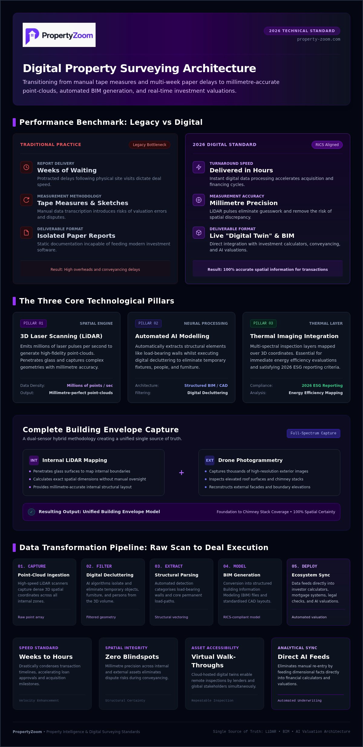
Digital property surveying represents a fundamental shift in how we understand and value physical assets. By 2026, the reliance on manual tape measures and hand-drawn sketches has become a legacy practice that modern investors simply can't afford. Today, the UK property market demands a standard that combines rapid delivery with absolute data integrity. This process uses advanced LiDAR sensors, AI-driven processing, and 3D imaging to convert a physical building into a precise digital asset. It’s no longer just a basic inspection; it’s the creation of a "Digital Twin" that serves both residential and commercial stakeholders throughout the entire property lifecycle.
This modern approach aligns seamlessly with RICS professional standards whilst significantly increasing output speed. Traditional methods often struggle with complex geometries or large-scale commercial sites, but digital tools capture every angle with millimetre precision. This rich data set feeds directly into broader property management systems. It ensures that valuations and structural assessments are based on 100% accurate spatial information, reducing the risk of costly errors during the conveyancing phase.
The Core Components of a Digital Survey
The transition to a digital-first workflow relies on three critical technological pillars. These tools work in tandem to provide a comprehensive view of any asset with minimal delay.
- 3D Laser Scanning (LiDAR): This technology captures millions of data points per second. It creates point-clouds that result in millimetre-perfect floor plans, removing the guesswork from property dimensions and structural layouts.
- Automated AI Modelling: Raw data is instantly processed into structured Building Information Modeling (BIM) files. This allows for rapid CAD generation and smarter asset management across the building’s life.
- Thermal Imaging Integration: Modern surveys often include thermal layers. This is essential for energy efficiency assessments and meeting 2026 ESG reporting requirements for commercial portfolios.
Digital vs. Traditional Surveying: The Key Differences
Efficiency is the primary driver behind the adoption of digital property surveying. When we compare the two methods, the gap in performance is stark and impacts the entire transaction timeline.
Speed is the most immediate benefit for the user. A traditional survey might take weeks to produce a final report after the initial site visit. Digital processing reduces this to hours. Accuracy also sees a massive boost. By eliminating manual data transcription, you remove the risk of human error that often leads to valuation disputes or structural surprises. Finally, accessibility is transformed. Stakeholders can view and interact with property data from any global location via secure cloud platforms, making the "site visit" a virtual, repeatable, and transparent experience.
The Technology Behind the Scan: LiDAR, BIM, and AI Modelling
Digital property surveying isn't just about taking high-resolution pictures. It’s about capturing high-fidelity data that serves as a single source of truth for every stakeholder. Modern scanners emit millions of laser pulses to map every surface within a building. This creates a point-cloud, a dense collection of 3D coordinates that define the building's geometry with absolute precision. This raw data engine powers everything from virtual walk-throughs to complex structural analysis.
LiDAR and Photogrammetry: Capturing Reality
LiDAR is the gold standard for verifying structural integrity. It penetrates through glass and captures precise dimensions that manual tools frequently miss. For external surveying, drone photogrammetry takes over. Drones capture thousands of high-resolution images of roofs and elevations to create a detailed map of the building's exterior. By combining these internal and external data sets, you get a complete building envelope model. This hybrid approach ensures no detail is overlooked, from the foundation to the chimney stack, providing a level of detail that traditional site visits can't match.
AI-Powered Modelling and Data Extraction
The real magic happens during the data processing phase. AI identifies structural features like load-bearing walls automatically, allowing for immediate structural analysis without manual oversight. It also performs "digital decluttering". AI algorithms recognise and remove furniture, people, and temporary fixtures from the scan. This leaves a clean, structural floor plan that focuses purely on the asset’s permanent features.
Raw data then moves into structured formats. By following RICS Data Standards, these scans are converted into IFC, RVT, and DWG formats for architects and engineers. This allows for the instant generation of room data sheets and energy consulting reports. Centralising this data amongst stakeholders ensures transparent decision-making. Everyone looks at the same digital twin, which removes the friction typically found in property deals. If you want to see how this tech integrates with your portfolio, explore the PropertyZoom ecosystem for a more intelligent way to manage assets and valuations.
Analysing the Benefits: Why Digital Surveys are a Game-Changer for Investors
Digital property surveying removes the ambiguity that frequently stalls high-value property deals. Instead of waiting weeks for a manual report, investors now receive instant data that satisfies lenders and underwriters immediately. This transparency is vital for maintaining momentum in a competitive market. By providing a clear, verifiable record of an asset's condition, you eliminate the friction that typically occurs during the due diligence phase. It’s a pragmatic solution for those who value speed and clarity over traditional, slow-moving paperwork.
Precision is the foundation of a reliable instant property valuation online. When AI models ingest millimetre-accurate dimensions rather than rough estimates, the margin of error for valuations vanishes. This allows for tighter financial planning and more aggressive bidding strategies. You can act with confidence, knowing your offer is backed by hard data rather than optimistic guesses. This level of accuracy is particularly beneficial when managing large portfolios where small errors in square footage can lead to significant valuation discrepancies.
Renovation potential becomes much easier to quantify with a digital twin. You can overlay proposed architectural changes onto a 3D model to calculate exact material costs and projected yield. This detailed insight boosts confidence amongst international buyers who cannot visit the site in person. They can explore the property virtually, trust the measurements, and make informed, data-driven decisions from anywhere in the world. Digital surveys turn a physical asset into a transparent, liquid investment opportunity.
Faster Appraisals and Investment Scores
Modern AI property search platforms now integrate survey data to refine search results and yield predictions. This improves the accuracy of investment scores by factoring in real structural data rather than just postcode averages. Thermal scanning adds another layer of intelligence by identifying hidden risks like damp or significant heat loss before you commit capital. You get a comprehensive view of the property's performance metrics, allowing you to filter out high-risk assets instantly and focus on those with the best growth potential.
Streamlining the Conveyancing Process
The legal phase often slows to a crawl over physical discrepancies or boundary questions. Integrated property legal services online use digital surveys to resolve boundary disputes with photographic and laser-measured evidence. Having this clear data ready provides solid ground for mortgage applications and insurance quotes. It also protects you from the risk of "gazundering" by revealing structural issues early in the process. You ensure that the price you agree at the start is the price you pay at completion, protecting your ROI from late-stage surprises.
How to Implement Digital Surveying in Your Property Workflow
Implementing digital property surveying into your existing workflow is a straightforward transition that yields immediate operational gains. The process starts with a clear assessment of your asset type. Student accommodation listings require high-density room data for leasing, whilst commercial assets often demand full structural BIM for complex facility management. Once you’ve defined the scope, you can follow these four steps to modernise your approach:
- Step 1: Identify Requirements. Determine the depth of data needed based on the property type and your investment goals.
- Step 2: Select a Centralised Platform. Choose a hub that integrates surveying, legal, and mortgage data to avoid information silos.
- Step 3: Schedule the Professional Scan. Use a vetted partner network to ensure RICS-compliant data capture and rapid turnaround.
- Step 4: Integrate Results. Feed the survey data directly into your streamlined property buying process for faster decision-making.
By adopting digital property surveying, you ensure every decision-maker has access to the same high-fidelity data at the same time. This synchronisation is the key to closing deals whilst competitors are still waiting for paper reports to arrive.
Choosing the Right Level of Digital Detail
Not every project requires a full digital twin. A simple 2D floor plan is often enough for standard residential valuations. However, full BIM is essential for major renovations or commercial developments. Assess the value of thermal imaging for older UK properties to identify heat loss early. You should also ensure your chosen data format is compatible with your architect’s software, such as Revit or AutoCAD, to avoid conversion delays. Matching the detail level to the project scope saves both time and budget.
Managing Portfolios with Digital Building Data
For those managing multiple assets, organisation is key. Centralise your surveys in a single cloud-based dashboard to track the condition of your entire portfolio. Use this data for ongoing property maintenance and facility management. Sharing these high-fidelity models with prospective tenants or buyers accelerates the leasing cycle. It provides a transparent view of the space before they even step foot inside. To start building your digital-ready portfolio, access PropertyZoom’s integrated surveying tools and streamline your next acquisition.
Streamlining Transactions with PropertyZoom’s Integrated Ecosystem
PropertyZoom bridges the gap between raw data collection and successful transaction completion. Whilst competitors focus on the technical specs of hardware, we focus on the transactional outcome: a completed property deal. Our ecosystem connects you with digital-ready surveying professionals who understand the 2026 market requirements. By centralising digital property surveying data alongside AI valuations and legal conveyancing, we remove the friction of jumping between different service providers.
ZEBA AI acts as your high-tech assistant, interpreting complex survey reports to highlight critical investment risks instantly. Instead of reading through fifty pages of technical jargon, you get a concise summary of how the survey impacts your yield and structural integrity. This integration reduces the total time to buy from months to just a few weeks. It’s a pragmatic approach designed for investors who want to move at the speed of the digital economy.
The PropertyZoom Advantage for Investors
Investors targeting niche markets gain a significant edge through our verified data streams. Accessing student accommodation listings becomes effortless when the structural data is already pre-verified and ready for review. This level of transparency builds trust and allows for faster capital deployment.
- AI Investment Scores: We incorporate structural survey insights directly into your ROI calculations for maximum accuracy.
- Zeba Calls AI: Book your surveyor appointments instantly through our conversational AI, removing the need for back-and-forth emails.
- Data Centralisation: View your survey, mortgage status, and legal progress in one unified, high-speed dashboard.
Future-Proofing Your Real Estate Strategy
In 2026, digital property surveying is no longer optional for those managing ESG-compliant portfolios. Accurate thermal data and structural modelling are essential for meeting environmental reporting standards. Holding digital building data also adds significant long-term value to your asset. When you decide to sell, providing a complete "digital twin" to the next buyer accelerates their due diligence and justifies a premium price.
The transition to a smarter workflow starts with a single scan. You can request your first digital survey through the platform today to see how integrated data transforms your acquisition speed. This is the future of real estate: transparent, fast, and driven by intelligence.
Master the 2026 Property Market with Data-Led Precision
The shift towards data-driven real estate is no longer a future concept; it’s the 2026 standard for high-performance investors. You now understand how LiDAR and AI modelling eliminate human error whilst slashing transaction timelines from months to weeks. By adopting digital property surveying, you remove the structural ambiguity that often stalls complex deals. This technology provides the millimetre-perfect clarity needed to back aggressive bids and secure high-yield assets before the competition even receives a paper report.
Efficiency in today's market requires a centralised approach that connects physical data with financial outcomes. PropertyZoom provides a sophisticated ecosystem powered by ZEBA AI, delivering instant valuations and investment scores alongside a professional referral network for surveying and legal services. You can now manage every stage of your acquisition within a single, high-speed workflow that prioritises your time and peace of mind. Every obstacle between you and your next investment is being removed by smarter technology.
Streamline your property buying with PropertyZoom’s digital ecosystem. The path to faster, smarter real estate decisions is now effortless and transparent. Start your journey today and experience the confidence of a truly digital investment strategy.
Frequently Asked Questions
Is a digital property survey as accurate as a traditional one?
Digital surveys are significantly more accurate than traditional methods because they eliminate human error. Using LiDAR technology, these scans capture millimetre-perfect dimensions that manual tape measures often miss. This high-fidelity data ensures your floor plans and structural models are 100% reliable. It provides a solid foundation for valuations and architectural planning, giving you total confidence in the physical data of your asset from the very start.
How much does digital property surveying cost in the UK?
The cost of digital property surveying in the UK varies based on the property’s size, location, and the level of detail required. A simple 2D floor plan for a residential flat is naturally more affordable than a full BIM model for a large commercial complex. Most industry professionals report that whilst the initial cost may differ from traditional visits, the long-term savings from reduced errors and faster transaction speeds provide superior value.
Can digital surveys be used for RICS Level 2 and Level 3 reports?
Digital surveys are perfect for supporting RICS Level 2 and Level 3 reports in 2026. Whilst the surveyor still provides their professional judgment, digital data acts as the primary evidence base for their findings. It allows for more detailed structural analysis and provides a permanent, visual record of the property’s condition at the time of inspection. This combination of tech and expertise ensures your report meets the highest industry standards.
How long does a digital property survey take to complete?
A digital property survey is remarkably fast, often taking only a few hours to complete on-site. Once the scan is finished, AI-powered processing can generate structured models and reports in less than 24 hours. This is a massive improvement over traditional methods that frequently take weeks to produce a final document. You get the insights you need almost instantly, allowing you to move forward with your acquisition without unnecessary delays.
What file formats will I receive from a digital building survey?
You will typically receive a variety of industry-standard file formats that are compatible with modern architectural and engineering software. These include IFC, RVT, and DWG files for CAD and BIM integration. Most providers also offer high-resolution 2D PDF floor plans and access to interactive 3D virtual walkthroughs. Having your building data in these formats makes it easy to share with contractors, architects, or prospective tenants throughout the property's lifecycle.
Do I need a digital survey for student accommodation or commercial land?
Digital surveys are highly recommended for student accommodation and commercial land acquisitions. For student listings, precise unit density and room dimensions are critical for calculating accurate yields. On commercial land, drone photogrammetry provides a comprehensive view of topography and boundaries that manual inspections can't replicate. Using digital property surveying for these niche assets ensures your investment scores are based on the most accurate structural and spatial data available.
Can digital surveying help with energy efficiency and EPC ratings?
Digital surveying is a powerful tool for improving energy efficiency and securing better EPC ratings. Integrated thermal imaging identifies heat loss, cold spots, and hidden damp issues that aren't visible to the naked eye. This data allows you to plan targeted retrofitting projects that maximise your energy performance. In 2026, having this digital evidence is essential for maintaining an ESG-compliant portfolio and proving the long-term sustainability of your assets.
How does PropertyZoom integrate with digital surveying services?
PropertyZoom integrates surveying services directly into its digital ecosystem to create a seamless buying experience. Our platform connects you with a professional referral network of digital-ready surveyors who deliver data in real-time. This information feeds into our AI Valuations and Investment Scores, ensuring your financial projections are backed by physical facts. By centralising surveying, legal work, and mortgages, we help you manage your entire transaction within one high-speed, intelligent dashboard.


